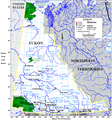
File:Yukonwikimap.PNG
外观

本预览的尺寸:559 × 600像素。 其他分辨率:224 × 240像素 | 447 × 480像素 | 863 × 926像素。
原始文件 (863 × 926像素,文件大小:96 KB,MIME类型:image/png)
文件历史
点击某个日期/时间查看对应时刻的文件。
| 日期/时间 | 缩略图 | 大小 | 用户 | 备注 | |
|---|---|---|---|---|---|
| 当前 | 2010年6月13日 (日) 12:29 |  | 863 × 926(96 KB) | Jahoe | For some reason this map exists both on commons and English wikipedia, using the same file name. It turned out that the one here on commons was an old version (with the longitudes reversed). This upload synchronizes both versions. |
| 2006年9月21日 (四) 00:38 |  | 863 × 926(169 KB) | Góngora | Map of the Yukon created by Earl Andrew, a wikipedian belonging to English Wikipedia. {{PD|Earl Andrew}} |
文件用途
全域文件用途
以下其他wiki使用此文件:
- af.wikipedia.org上的用途
- be-tarask.wikipedia.org上的用途
- ca.wikipedia.org上的用途
- de.wikipedia.org上的用途
- en.wikipedia.org上的用途
- es.wikipedia.org上的用途
- fr.wikipedia.org上的用途
- fy.wikipedia.org上的用途
- gl.wikipedia.org上的用途
- hi.wikipedia.org上的用途
- hy.wikipedia.org上的用途
- id.wikipedia.org上的用途
- ilo.wikipedia.org上的用途
- it.wikipedia.org上的用途
- Liard
- Geografia dello Yukon
- Fiumi dello Yukon
- Peel (fiume Canada)
- Wind (fiume)
- Teslin (fiume)
- Snake (fiume Yukon)
- Donjek
- Firth (fiume)
- Aishihik (fiume)
- Dezadeash
- Bonnet Plume
- Blackstone (fiume Yukon)
- Hart (fiume)
- Big Salmon
- Frances (fiume)
- Hyland (fiume)
- La Biche (affluente Liard)
- Babbage (fiume)
- Smith (fiume)
- Indian (fiume Yukon)
- Kaskawulsh
- ja.wikipedia.org上的用途
- mn.wikipedia.org上的用途
- nl.wikipedia.org上的用途
查看此文件的更多全域用途。


