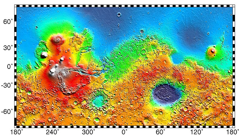
File:Mars Map.JPG
外观

本预览的尺寸:800 × 457像素。 其他分辨率:320 × 183像素 | 640 × 365像素 | 1,024 × 584像素 | 1,280 × 730像素 | 2,180 × 1,244像素。
原始文件 (2,180 × 1,244像素,文件大小:2.33 MB,MIME类型:image/jpeg)
文件历史
点击某个日期/时间查看对应时刻的文件。
| 日期/时间 | 缩略图 | 大小 | 用户 | 备注 | |
|---|---|---|---|---|---|
| 当前 | 2019年5月4日 (六) 02:57 |  | 2,180 × 1,244(2.33 MB) | Huntster | Full resolution from NASA/JPL. |
| 2014年5月6日 (二) 09:23 |  | 613 × 350(139 KB) | Wikiuser13 | Transferred from en.wikipedia |
文件用途
以下45个页面使用本文件:
- 乌托邦平原
- 亞馬遜平原 (火星)
- 内彭西斯桌山群
- 冰川 (火星)
- 凤凰号火星探测器
- 勇气号火星探测器
- 古瑟夫撞擊坑
- 吕多陨击坑
- 埃里达尼亚平原
- 塔尔西斯山群
- 天问一号
- 奥克塔维娅·埃·巴特勒着陆场
- 好奇號
- 小獵犬2號
- 布拉德伯里着陆场
- 旅居者號
- 普罗米修高地
- 机遇号火星漫游车
- 毅力号火星探测器
- 沙拉德雷达
- 海盗号着陆器生物探测实验
- 火星2020時間軸
- 火星3號
- 火星人造物体列表
- 火星地理
- 火星岩石列表
- 火星探路者
- 火星水文
- 火星生命
- 火星登陆
- 示巴高地
- 祝融号火星车
- 米氏陨击坑
- 米蘭科維奇撞擊坑 (火星)
- 維京1號
- 維京2號
- 維京号
- 羅莎琳·富蘭克林號
- 辛梅利亞高地
- 阿尔巴山
- 阿拉伯台地 (火星)
- Template:火星交互式地图
- Template:火星地图
- Template:火星特征和纪念地地图
- Template:火星表面探测器地图
全域文件用途
以下其他wiki使用此文件:
- ar.wikipedia.org上的用途
- az.wikipedia.org上的用途
- be.wikipedia.org上的用途
- bn.wikipedia.org上的用途
- bs.wikipedia.org上的用途
- ca.wikipedia.org上的用途
- Opportunity
- Escala de temps geològics de Mart
- Mars Pathfinder
- Programa Viking
- Mars rover
- Phoenix (sonda)
- Spirit
- Viking 1
- Geografia de Mart
- Viking 2
- Beagle 2
- Aigua a Mart
- Astromòbil
- Mòdul de descens
- Curiosity
- Objectes artificials a la superfície de Mart
- Mars Polar Lander
- Mars 6
- Mars 3
- Usuari:Mcapdevila/Exploració de Mart
- Deep Space 2
- Rosalind Franklin (astromòbil)
- Exploració de Mart
查看此文件的更多全域用途。


