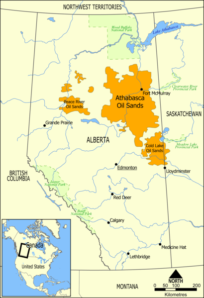
File:Athabasca Oil Sands map.png
外观

本预览的尺寸:410 × 599像素。 其他分辨率:164 × 240像素 | 328 × 480像素 | 526 × 768像素 | 1,200 × 1,753像素。
原始文件 (1,200 × 1,753像素,文件大小:611 KB,MIME类型:image/png)
文件历史
点击某个日期/时间查看对应时刻的文件。
| 日期/时间 | 缩略图 | 大小 | 用户 | 备注 | |
|---|---|---|---|---|---|
| 当前 | 2006年5月10日 (三) 16:49 |  | 1,200 × 1,753(611 KB) | NormanEinstein | This map shows the extent of the oils sands in Alberta, Canada. The three oil sand deposits are known as the Athabasca Oil Sands, the Cold Lake Oil Sands, and the Peace River Oil Sands. Created by NormanEinstein, May 10, 2006. {{GFDL-self}} [[Category: |
文件用途
全域文件用途
以下其他wiki使用此文件:
- ar.wikipedia.org上的用途
- bg.wikipedia.org上的用途
- ca.wikipedia.org上的用途
- cs.wikipedia.org上的用途
- da.wikipedia.org上的用途
- de.wikipedia.org上的用途
- el.wikipedia.org上的用途
- en.wikipedia.org上的用途
- Ernest Manning
- Oil sands
- Athabasca oil sands
- User:NormanEinstein/gallery
- Template:Text-superimpose
- Wabasca oil field
- History of the petroleum industry in Canada (oil sands and heavy oil)
- Kearl Oil Sands Project
- Cold Lake oil sands
- Peace River oil sands
- Oil sands tailings ponds (Canada)
- Tar Sands Healing Walk
- User:Klausronjaen/sandbox
- Georg Naumann
- Environmental issues in Alberta
- Timeline of the petroleum industry in Alberta
- Template:Text-superimpose/doc
- Template:Text-superimpose/sandbox
- History of the Petroleum industry in Alberta
- Legacy pollution
- User:Spencerladner/Legacy pollution
- en.wikinews.org上的用途
- es.wikipedia.org上的用途
- fa.wikipedia.org上的用途
- fi.wikipedia.org上的用途
- fr.wikipedia.org上的用途
- gl.wikipedia.org上的用途
- he.wikipedia.org上的用途
- it.wikipedia.org上的用途
- ja.wikipedia.org上的用途
查看此文件的更多全域用途。

