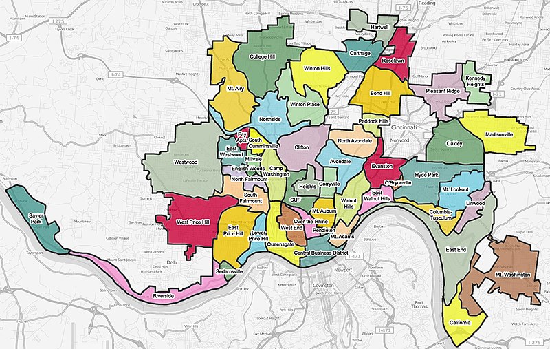
File:All-Neighborhoods-Cincinnati.jpg
外觀

預覽大小:800 × 507 像素。 其他解析度:320 × 203 像素 | 640 × 406 像素 | 1,024 × 649 像素 | 1,332 × 844 像素。
原始檔案 (1,332 × 844 像素,檔案大小:445 KB,MIME 類型:image/jpeg)
檔案歷史
點選日期/時間以檢視該時間的檔案版本。
| 日期/時間 | 縮圖 | 尺寸 | 使用者 | 備註 | |
|---|---|---|---|---|---|
| 目前 | 2008年8月6日 (三) 05:41 |  | 1,332 × 844(445 KB) | Wholtone | {{Information |Description=Fixed spelling of "Cumminsville." |Source=http://www.openstreetmap.org/ |Date=August 6, 2008 |Author=Wholtone |Permission={{cc-by-sa-2.0}} |other_versions= }} Category:Maps |
| 2008年8月5日 (二) 03:27 |  | 1,332 × 844(445 KB) | Wholtone | {{Information |Description=A colored map of neighborhoods within Cincinnati, Ohio. Neighborhood lines are based roughly on neighborhood information from http://www.cincinnati-oh.gov/police/pages/-5095-/ and http://www.cincinnati-oh.gov/cdap/downloads/cdap | |
| 2008年8月4日 (一) 02:43 |  | 1,332 × 844(454 KB) | Wholtone | {{Information |Description=A colored map of neighborhoods within Cincinnati, Ohio. Neighborhood lines may not be perfectly exact at the street level, and are based on neighborhood information on http://www.cincinnati-oh.gov/police/pages/-5095-/. This stre | |
| 2008年8月4日 (一) 02:22 |  | 1,332 × 844(454 KB) | Wholtone | {{Information |Description=A colored map of neighborhoods within Cincinnati, Ohio. Neighborhood lines may not be perfectly exact at the street level, and are based on neighborhood information on http://www.cincinnati-oh.gov/police/pages/-5095-/. This stre | |
| 2008年8月4日 (一) 02:18 |  | 1,332 × 844(475 KB) | Wholtone | {{Information |Description={{en|1=A colored map of neighborhoods within Cincinnati, Ohio. Neighborhood lines may not be perfectly exact at the street level, and are based on neighborhood information on http://www.cincinnati-oh.gov/police/pages/-5095-/. Th |
檔案用途
下列頁面有用到此檔案:
全域檔案使用狀況
以下其他 wiki 使用了這個檔案:
- en.wikipedia.org 的使用狀況
- en.wikivoyage.org 的使用狀況
- es.wikivoyage.org 的使用狀況
- fr.wikipedia.org 的使用狀況
- it.wikivoyage.org 的使用狀況
- vep.wikipedia.org 的使用狀況
- www.wikidata.org 的使用狀況

