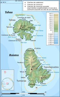
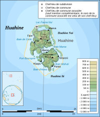
File:Leeward Islands (Society Islands) topographic map-fr.svg
外觀

此 SVG 檔案的 PNG 預覽的大小:800 × 400 像素。 其他解析度:320 × 160 像素 | 640 × 320 像素 | 1,024 × 512 像素 | 1,280 × 640 像素 | 2,560 × 1,280 像素 | 2,000 × 1,000 像素。
原始檔案 (SVG 檔案,表面大小:2,000 × 1,000 像素,檔案大小:1.6 MB)
檔案歷史
點選日期/時間以檢視該時間的檔案版本。
| 日期/時間 | 縮圖 | 尺寸 | 使用者 | 備註 | |
|---|---|---|---|---|---|
| 目前 | 2008年11月23日 (日) 16:14 |  | 2,000 × 1,000(1.6 MB) | Sardon | {{Information |Description= |Source= |Date= |Author= |Permission= |other_versions= }} |
| 2008年11月16日 (日) 20:14 |  | 2,000 × 1,000(1.62 MB) | Sardon | {{Information |Description= |Source= |Date= |Author= |Permission= |other_versions= }} | |
| 2008年11月16日 (日) 20:12 |  | 2,000 × 1,000(674 KB) | Sardon | {{Information |Description= |Source= |Date= |Author= |Permission= |other_versions= }} | |
| 2008年11月9日 (日) 10:16 |  | 2,455 × 1,743(536 KB) | Sardon | {{Information |Description={{en|1=Topographic map in French of the islands of Huahine, Raiatea, Tahaa, Bora Bora and Tupai, Society Islands, French Polynesia.}} {{fr|1=Carte top |
檔案用途
下列頁面有用到此檔案:
全域檔案使用狀況
以下其他 wiki 使用了這個檔案:
- af.wikipedia.org 的使用狀況
- als.wikipedia.org 的使用狀況
- ar.wikipedia.org 的使用狀況
- br.wikipedia.org 的使用狀況
- en.wikipedia.org 的使用狀況
- eo.wikipedia.org 的使用狀況
- es.wikipedia.org 的使用狀況
- eu.wikipedia.org 的使用狀況
- fa.wikipedia.org 的使用狀況
- fi.wikipedia.org 的使用狀況
- fr.wikipedia.org 的使用狀況
- Géographie de la Polynésie française
- Archipel de la Société
- Utilisateur:Sardon
- Wikipédia:Atelier graphique/Cartes/Archives/novembre 2008
- Liste des souverains des îles Raiatea, Huahine et Bora-Bora
- Wikipédia:Atelier graphique/Cartes/Archives/décembre 2015
- Utilisateur:Exp JC/Brouillon
- Relations entre la France et les pays et territoires d'Océanie
- gl.wikipedia.org 的使用狀況
- hu.wikipedia.org 的使用狀況
- mk.wikipedia.org 的使用狀況
- nl.wikipedia.org 的使用狀況
- no.wikipedia.org 的使用狀況
- pl.wikipedia.org 的使用狀況
- pt.wikipedia.org 的使用狀況
- ru.wikipedia.org 的使用狀況
- tr.wikipedia.org 的使用狀況
- ty.wikipedia.org 的使用狀況
- zh-yue.wikipedia.org 的使用狀況


