跳至內容

File:20080929-laura-full.jpg

頁面內容不支援其他語言。
這個檔案來自維基共享資源
維基百科,自由的百科全書

原始檔案 (6,431 × 7,806 像素,檔案大小:34.11 MB,MIME 類型:image/jpeg


摘要

描述
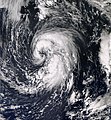
English: In late September, a large non-tropical system located over the north-central Atlantic slowly moved westward away from the Azores. The low produced hurricane-force winds, but did not exhibit the characteristics of a tropical cyclone. The storm steadily weakened over the following days, but developed tropical characteristics as it moved over slightly warmer waters.

By September 29, the low had developed sufficient convection and was declared Subtropical Storm Laura. Upon being upgraded, cold cloud tops began to wrap around the center of Laura and consolidate near the center of circulation. The convection organized around the center quickly and a satellite pass over the storm revealed that it could be intensifying. A later satellite pass disregarded the possibility of intensification as the intensity was confirmed to be at 60 mph (95 km/h). The overall structure of Laura remained subtropical but there were indications that it might have been acquiring tropical characteristics.

As of 11 p.m. AST September 29 (0300 UTC September 30), Subtropical Storm Laura is located within 20 nautical miles of 38.3°N 48.4°W, about 585 mi (940 km) south-southeast of Cape Race, Newfoundland and Labrador. Maximum sustained winds are 50 knots (60 mph, 95 km/h), with stronger gusts. Minimum central pressure is 995 mbar (hPa; 29.38 InHg), and the system is moving north at 8 kt (9 mph, 15 km/h).
日期
來源 NASA Worldview
作者 NASA
授權許可
(重用此檔案)
Public domain

授權條款

Public domain 本作品由NASA創作,屬於公有領域。根據NASA的版權政策:“NASA的創作除非另有聲明否則不受版權保護。”(參見:Template:PD-USGov/zhNASA版權政策JPL圖像使用政策
警告:

說明

添加單行說明來描述出檔案所代表的內容

在此檔案描寫的項目

描繪內容

著作權狀態 繁體中文 (已轉換拼寫)

斷定方法:​美國聯邦政府的作品 繁體中文 (已轉換拼寫)

多媒體型式 繁體中文 (已轉換拼寫)

image/jpeg

校驗和 繁體中文 (已轉換拼寫)

66c22e9f01d8c53d113f9bb4eee18a6c7f234a6f

斷定方法:​SHA-1 中文 (已轉換拼寫)

資料大小 Chinese (Hong Kong) (已轉換拼寫)

35,768,065 位元組

7,806 像素

6,431 像素

檔案歷史

點選日期/時間以檢視該時間的檔案版本。

日期/時間縮⁠圖尺寸用戶備⁠註
目前2013年4月2日 (二) 11:31於 2013年4月2日 (二) 11:31 版本的縮圖6,431 × 7,806(34.11 MB)SupportstormGeo-rectify
2013年3月26日 (二) 05:51於 2013年3月26日 (二) 05:51 版本的縮圖7,329 × 7,915(11.07 MB)Earth100250 meter res, better quality.

全域檔案使用狀況

以下其他 wiki 使用了這個檔案:

詮釋資料