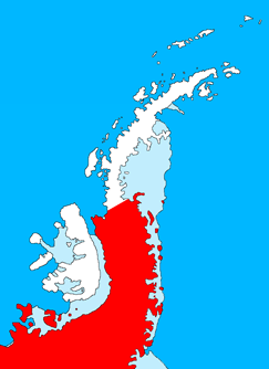
File:PalmerLandstubmap.png
外观
PalmerLandstubmap.png (243 × 334像素,文件大小:32 KB,MIME类型:image/png)
文件历史
点击某个日期/时间查看对应时刻的文件。
| 日期/时间 | 缩略图 | 大小 | 用户 | 备注 | |
|---|---|---|---|---|---|
| 当前 | 2011年7月9日 (六) 20:09 |  | 243 × 334(32 KB) | MGA73bot2 | {{BotMoveToCommons|en.wikipedia|year={{subst:CURRENTYEAR}}|month={{subst:CURRENTMONTHNAME}}|day={{subst:CURRENTDAY}}}} {{Information |Description={{en|Outline map of the Antarctic Peninsula showing en:Palmer Land. Drawn by me (User:Grutness) base |
文件用途
全域文件用途
以下其他wiki使用此文件:
- az.wikipedia.org上的用途
- de.wikipedia.org上的用途
- en.wikipedia.org上的用途
- Palmer Land
- Wordie Ice Shelf
- Skytrain Ice Rise
- Orville Coast
- Black Coast
- Dolleman Island
- Wilkins Coast
- Rothschild Island
- Dyer Plateau
- Mount Ward (Antarctica)
- English Coast
- Cape Jeremy
- Smyley Island
- Utopia Glacier
- Shabica Glacier
- Airy Glacier
- Faure Islands
- Zephyr Glacier
- Zonda Glacier
- Zonda Towers
- Zumberge Coast
- Jaeger Hills
- Haag Nunataks
- Auriga Nunataks
- Simpson Hills
- Procyon Peaks
- Prospect Glacier
- Mount Castro
- George VI Ice Shelf
- Eklund Islands
- Desko Mountains
- Bates Peak
- Enigma Peak
- Goward Peak
- Morrill Peak
- Thuma Peak
- Overton Peak
- Willey Glacier
- Wright Spires
- Mount Allan (Antarctica)
查看此文件的更多全域用途。


