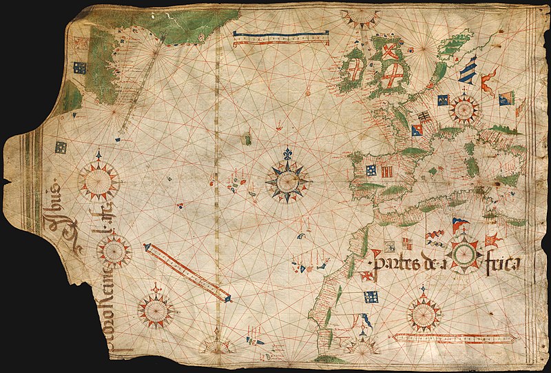
File:Pedro Reinel 1504.jpg
外觀

預覽大小:800 × 541 像素。 其他解析度:320 × 216 像素 | 640 × 433 像素 | 1,024 × 693 像素 | 1,280 × 866 像素 | 2,560 × 1,732 像素 | 3,418 × 2,312 像素。
原始檔案 (3,418 × 2,312 像素,檔案大小:6 MB,MIME 類型:image/jpeg)
檔案歷史
點選日期/時間以檢視該時間的檔案版本。
| 日期/時間 | 縮圖 | 尺寸 | 使用者 | 備註 | |
|---|---|---|---|---|---|
| 目前 | 2008年10月11日 (六) 20:40 |  | 3,418 × 2,312(6 MB) | Alvesgaspar | {{Information |Description=Portuguese nautical chart by Pedro Reinel, c. 1504 |Source=Bayerische Staatsbibliothek, Munchen |Date=c. 1504 |Author=Pedro Reinel |Permission=below |other_versions= }} Category:Photos by Alvesgaspar Category:Old charts |
檔案用途
下列2個頁面有用到此檔案:
全域檔案使用狀況
以下其他 wiki 使用了這個檔案:
- bn.wikipedia.org 的使用狀況
- ca.wikipedia.org 的使用狀況
- crh.wikipedia.org 的使用狀況
- cs.wikipedia.org 的使用狀況
- cv.wikipedia.org 的使用狀況
- de.wikipedia.org 的使用狀況
- en.wikipedia.org 的使用狀況
- User:Alvesgaspar
- Pedro Reinel
- History of cartography
- Portal:Maps/Selected picture
- Wikipedia:Featured pictures/Diagrams, drawings, and maps/Maps
- Wikipedia:Featured pictures thumbs/13
- Wikipedia:Featured picture candidates/October-2008
- Wikipedia:Featured picture candidates/Image:Pedro Reinel 1504.jpg
- Wikipedia:Wikipedia Signpost/2008-11-08/Features and admins
- Wikipedia:Wikipedia Signpost/2008-11-08/SPV
- Portal:Maps/Selected picture/46
- Wikipedia:Picture of the day/June 2009
- Template:POTD/2009-06-18
- User talk:Alvesgaspar/archive1
- User:Peter Mercator/Map gallery
- Portuguese Renaissance
- Wikipedia:GLAM/NHMandSM/booklet
- Portal:Maps
- Wikipedia:Wikipedia Signpost/Single/2008-11-08
- en.wiktionary.org 的使用狀況
- eo.wikipedia.org 的使用狀況
- Vikipedio:Bildo de la tago/2009 01
- Vikipedio:Bildo de la tago/2009 02
- Pedro Reinel
- Vikipedio:Bildo de la tago/2011 02
- Vikipedio:Bildo de la tago/2011 01
- Vikipedio:Bildo de la tago/2010 02
- Vikipedio:Bildo de la tago/2010 01
- Vikipedio:Bildo de la tago/2012 02
- Vikipedio:Bildo de la tago/2012 01
- Vikipedio:Bildo de la tago2/indekso/3
- Ŝablono:Bildo de la Tago2/128
- es.wikipedia.org 的使用狀況
- es.wiktionary.org 的使用狀況
- fi.wikipedia.org 的使用狀況
- fr.wikipedia.org 的使用狀況
- fr.wiktionary.org 的使用狀況
檢視此檔案的更多全域使用狀況。


