跳至內容

File:Renoir crater.jpg

頁面內容不支援其他語言。
這個檔案來自維基共享資源
維基百科,自由的百科全書

原始檔案 (1,367 × 1,393 像素,檔案大小:1.14 MB,MIME 類型:image/jpeg


摘要

描述
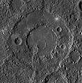
English: Renoir crater on Mercury, photo taken by the MESSENGER spacecraft and released on 17 August 2012.

Instrument: Wide Angle Camera (WAC) of the Mercury Dual Imaging System (MDIS)
Latitude Rang: 15° S to 22° S
Longitude Range: 304° E to 312° E
Resolution: 213 meters/pixel
Scale: Renoir is approximately 215 km (134 mi.) in diameter
Projection: Equirectangular
Of Interest: Today's featured image highlights Renoir, one of Mercury's beautiful peak-ring basins. Renoir appears to be older than other basins like Raditladi and Rachmaninoff, with more degradation from subsequent cratering and modification by tectonic activity.

This mosaic was acquired as part of MDIS's high-incidence-angle base map. The high-incidence-angle base map is a major mapping activity in MESSENGER's extended mission and complements the surface morphology base map of MESSENGER's primary mission that was acquired under generally more moderate incidence angles. High incidence angles, achieved when the Sun is near the horizon, result in long shadows that accentuate the small-scale topography of geologic features. The high-incidence-angle base map is being acquired with an average resolution of 200 meters/pixel.
Français : Le cratère Renoir sur Mercure, photo pris par le vaisseau spatial MESSENGER et été publié le 17 août 2012.
日期
來源 https://messenger.jhuapl.edu/Explore/Science-Images-Database/gallery-image-939.html
作者 NASA/Johns Hopkins University Applied Physics Laboratory/Carnegie Institution of Washington

授權條款

Public domain 本作品由NASA創作,屬於公有領域。根據NASA的版權政策:“NASA的創作除非另有聲明否則不受版權保護。”(參見:Template:PD-USGov/zhNASA版權政策JPL圖像使用政策
警告:

說明

添加單行說明來描述出檔案所代表的內容

在此檔案描寫的項目

描繪內容

image/jpeg

檔案歷史

點選日期/時間以檢視該時間的檔案版本。

日期/時間縮⁠圖尺寸使用者備⁠註
目前2012年8月17日 (五) 21:00於 2012年8月17日 (五) 21:00 版本的縮圖1,367 × 1,393(1.14 MB)Keilana

下列頁面有用到此檔案:

全域檔案使用狀況

以下其他 wiki 使用了這個檔案:

詮釋資料