File:DEMBauges.png
外观

本预览的尺寸:669 × 599像素。 其他分辨率:268 × 240像素 | 536 × 480像素 | 858 × 768像素 | 1,143 × 1,024像素 | 1,858 × 1,664像素。
原始文件 (1,858 × 1,664像素,文件大小:1.34 MB,MIME类型:image/png)
文件历史
点击某个日期/时间查看对应时刻的文件。
| 日期/时间 | 缩略图 | 大小 | 用户 | 备注 | |
|---|---|---|---|---|---|
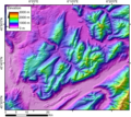
| 当前 | 2005年11月5日 (六) 00:29 |  | 1,858 × 1,664(1.34 MB) | Jide~commonswiki | DEM of the Bauges massifs (french Alps) created by Jide from the 90m pixel size SRTM dataset. The massif is located between the Bourget Lake (to the West) and the Annecy Lake (to the NE). The ENE-WSW valley to the South is the Isere valley downstrem to th |
文件用途
以下页面使用本文件:
全域文件用途
以下其他wiki使用此文件:

