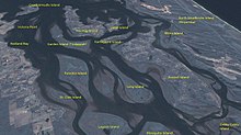
摩顿湾
外观
摩顿湾(英语:Moreton Bay)是位于澳大利亚昆士兰州府城布里斯本以东19公里的一处海湾,约形成于6,000年前,乃昆州最重要的海岸资源[1]。摩顿湾的水域是当地人最常亲近的一片天然休闲场所,也是近海渔民赖以为生的地方。
布里斯本港位于摩顿湾之北;广大平坦的地势,成为布里斯本机场和噪音污染的缓冲地带。由于此处拥有大片的沙滩,水产丰富,所以在欧洲人殖民初期,此地是新移民与澳大利亚原住民经常发生冲突的地方。
由于一连串外海岛屿影响限制了珊瑚海的海水流动,摩尔顿湾形势上更接近于一座潟湖。
历史
[编辑]摩尔顿湾大约在6000年前时,因为海平面上升将原本布里斯班河的泛滥平原给淹没而形成。
摩尔顿湾(澳大利亚原住民称为Quandamooka)及周边岛屿最早是澳大利亚原住民所居住栖息的地方, 1770年5月15日库克船长首次航行通过此地时,以英国皇家学会会长Lord Morton之名命名为Morton's Bay。[2] Moreton的写法是因为库克船长的航海纪录的第一次出版时误拼所造成[3]。

参考文献
[编辑]- ^ South East Queensland Regional Strategic Group. Strategic Guide to Natural Resource Management in South East Queensland. 2000: 56. ISBN 0734517408.
- ^ Environmental Protection Agency (Queensland). Heritage Trails of the Great South East. State of Queensland. 2000: 4. ISBN 0-7345-1008-X.
- ^ Ray Parkin, H. M. Bark Endeavour, Miegunyah Press, second edition 2003, ISBN 0-522-85093-6, page 226.
外部链接
[编辑]- 摩顿湾资料库
- 海湾日志 An online news source publishing one story a day about the Bay.
- 澳大利亚乡村歌谣:摩顿湾 (页面存档备份,存于互联网档案馆) Folk song about the penal colony at Moreton Bay
- Pencil drawing of Moreton Bay settlement, ca. 1835 by Henry Boucher Bowerman. Digitised and held by Heritage Collections, State Library of Queensland.
