曼哈頓市政大樓
外觀
曼哈頓市政大樓 | |
 | |
| 地點 | 紐約曼哈頓 |
|---|---|
| 坐標 | 40°42′46.67″N 74°0′13.99″W / 40.7129639°N 74.0038861°W |
| 建於 | 1907–1914[2] |
| 建築師 | 威廉 M.肯德爾 |
| 建築風格 | 文藝復興,其他 |
| NRHP編號 | 72000879[1] |
| 重要日期 | |
| NRHP收錄 | 1972年10月18日 |
| 指定NYCL | 1966年2月1日 |
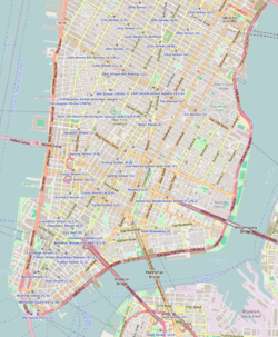
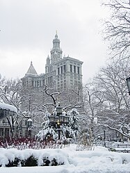
戴維丁金斯市政大樓(David N. Dinkins Municipal Building),原名曼哈頓市政大樓(Manhattan Municipal Building)[3],位於紐約曼哈頓中街1號(錢伯斯街和中街路口),高40層,580英尺(180公尺) ,是世界上最大的政府建築之一。
它是為適應1898年該市擴展到五個行政區以後政府空間需求增加而建造,於1907年開工,1914年結束,[2] 標誌着紐約城市美化運動的結束。著名的建築公司麥金、米德和懷特事務所的威廉 M.肯德爾設計了這座建築,地下納入了錢伯斯街地鐵站。目前,市政大樓內設十幾個市政機構,近100萬平方英尺的辦公空間,雇用2000餘人。[4]
影響
[編輯]市政大樓建築風格對其他美國城市的市政建設影響深遠,被描述為羅馬帝國,意大利文藝復興、法國文藝復興或布雜藝術等不同風格[5]。以它為原型的包括克利夫蘭的終點大廈(Terminal Tower)、芝加哥的箭牌大廈,以及斯大林時代的蘇聯建築莫斯科七姐妹。
該建築在1966年被指定為紐約市地標[2] ,於1972年列入國家史蹟名錄。2015年10月14日,該建築以前市長戴維·丁金斯命名[6]。
圖片
[編輯]參見
[編輯]- Municipal Building, New York City (頁面存檔備份,存於網際網路檔案館)—Emporis
- Katz, Chuck, Manhattan on Film: Walking Tours of Hollywood's Fabled Front Lot (頁面存檔備份,存於網際網路檔案館) (Limelight, 1995).
參考
[編輯]- ^ National Register Information System. National Register of Historic Places. National Park Service. 2006-03-15.
- ^ 2.0 2.1 2.2 New York City Landmarks Preservation Commission. Postal, Matthew A. (ed.). Dolkart, Andrew S.; Postal, Matthew A. (text). Guide to New York City Landmarks 4th. New York: John Wiley & Sons. 2009. ISBN 978-0-470-28963-1., p.33
- ^ The Municipal Building (頁面存檔備份,存於網際網路檔案館), New York Architecture.
- ^ Manhattan Municipal Building (頁面存檔備份,存於網際網路檔案館), New York City Department of Citywide Administrative Services (accessed September 27, 2015).
- ^ Sarah Bradford Landau & Carl W. Condit, Rise of the New York Skyscraper: 1865-1913 (Yale University Press, 1999), p. 374.
- ^ Ngo, Emily. "NYC Municipal Building renamed for former Mayor Dinkins" (頁面存檔備份,存於網際網路檔案館) Newsday (October 15, 2015)


