2010年薩赫勒饑荒
外觀


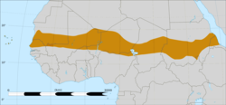
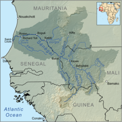
2010年2月至8月,非洲薩赫勒地區和鄰近的塞內加爾河流域地區的許多地方發生了大規模的饑荒。[1]
薩赫勒是非洲北部撒哈拉沙漠和南部蘇丹草原之間的生態氣候和生物地理過渡帶,面積305.32萬平方公里。它是一個含有半乾旱草原、疏林草原、草原和荊棘灌叢的過渡生態區。
鄰近的塞內加爾河流域地區的地方包括毛里塔尼亞、馬里、塞內加爾和幾內亞的部分或全部地區。據聯合國、非政府組織和塞內加爾河流域發展局表示,2009年當地的降雨量很低。[2][3]蘇丹棟古拉於2010年6月22日創下49.7°C (121.3 °F)的氣溫新紀錄。 [4]
概述
[編輯]在2009年底薩赫勒地區發生大雨後,2010年薩赫勒國家出現饑荒和糧食短缺,隨後又出現了熱浪,[5]影響範圍遍佈蘇丹、尼日爾、奈及利亞北部、喀麥隆北部、乍得、塞內加爾、布吉納法索,毛里塔尼亞、馬里以及鄰近的塞內加爾河地區的部分地區。 [2][3][6]
2009年12 月,美國國際開發署和一些非政府組織都預測,與2008年同期相比,馬里南部地區的糧食危機會進一步加劇。[7]
參考文獻
[編輯]- ^ Famine Drought Spreads Across Continent (頁面存檔備份,存於網際網路檔案館) Worldpress.org
- ^ 2.0 2.1 ACT Alert: Food Insecurity in Mauritania due to Drought situation in the Sahel region (頁面存檔備份,存於網際網路檔案館) Reuters AlertNet 引用錯誤:帶有name屬性「ReferenceA」的
<ref>標籤用不同內容定義了多次 - ^ 3.0 3.1 ACT Preliminary Appeal: Food insecurity in Mauritania due to Drought in the Sahel region (頁面存檔備份,存於網際網路檔案館) AlertNet 引用錯誤:帶有name屬性「ReferenceB」的
<ref>標籤用不同內容定義了多次 - ^ Masters, Jeff. NOAA: June 2010 the globe's 4th consecutive warmest month on record. Weather Underground. Jeff Masters' WunderBlog. [21 July 2010]. (原始內容存檔於19 July 2010).
- ^ "Strong risk" of 2010 famine in Africa's Sahel – EU (頁面存檔備份,存於網際網路檔案館) Reuters AlertNet
- ^ Mauritania heat wave kills 7 (頁面存檔備份,存於網際網路檔案館) Magharebia
- ^ Mali Food Security Outlook (頁面存檔備份,存於網際網路檔案館) PNADS238.pdf – Powered by Google Docs
