馬普爾渡槽
外觀
| 馬普爾渡槽 Marple Aqueduct | |
|---|---|
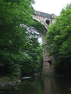
 The Marple Aqueduct from the River Goyt. | |
| 座標 | 53°24′26″N 2°04′08″W / 53.4072°N 2.06879°W[1] |
| OS格網參考 | |
| 承載 | Peak Forest Canal |
| 跨越 | River Goyt |
| 地點 | Marple, Greater Manchester |
| 維護單位 | Canal and river trust |
| 保護狀況 | 登錄建築 |
| 設計參數 | |
| 全長 | 105碼(96公尺) |
| 寬度 | 8英尺(2.4公尺) |
| 可通過 | No |
| 纖路 | Western side only |
| 跨數 | Three |
| 歷史 | |
| 設計師 | Benjamin Outram |
| 開工日 | 1795年 |
| 完工日 | 1799年 |
| 開通日 | 1800年 |
| 地圖 | |
 | |
馬普爾渡槽(英語:Marple Aqueduct)是一個渡槽,由設計師班傑明·奧特拉姆(Benjamin Outram)負責設計,駐地工程師托馬斯·布朗(Thomas Brown)完成建設。
圖冊
[編輯]-
Working boat traversing Marple Aqueduct
-
Working narrowboat on Marple Aqueduct, with the viaduct to the north
-
Working freight boat on Marple Aqueduct
-
The canal swings away, and passes under the railway viaduct.
-
It then enters the Marple flight of locks.
參考連結
[編輯]- Grahame Boyes and Brian Lamb, (2012) The Peak Forest Canal and Railway: an engineering and business history, Derby: Railway & Canal Historical Society


